Walking underwater in Okinawa with google underwater street view
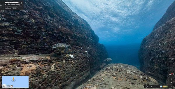
Underwater streetview lets users enjoy panoramic views of the Yonaguni underwater landscape.
March 2, 2017 Ryukyu Shimpo
The online search engine, Google, added eight underwater sites around Okinawa to the company’s map application, Underwater Street View. The application provides underwater panoramic views and lets its users enjoy “taking a walk” around sites including the best diving spots in Japan, Kerama Islands. Google started providing under water streetview in 2012 with photos featuring globally famous ocean destinations such as Australia, the Philippines, and Hawaii, however this is the first time the company has shown photos of the water around Japan.
The photographs were taken with support from the Okinawa Convention and Visitors Bureau (OCVB). Staff say they hope it will be a boost for tourism; “we would like to promote the beauty of Okinawa to home and abroad.”
There are eight new viewable areas including the biggest coral reef in Japan, Sekisei shoko coral reef, which covers the area between Ishigaki and the Miyako Islands, as well as the Yonaguni under water landscape, Kitahama in Aka Island, Nagura bay-giant potato in Ishigaki Island, Yamada point in Onna village, Taketomi Island, Zamami Island, and Aharen beach in Tokashiki Island.
Underwater photographer, Christophe Bailhache, shot Yamada point in Onna village in November 20, 2016. His photos will be among the new images in Google underwater streetview. A representative of Google said, “Many people cannot go underwater very easily. We would like to make dreams come true for those who would love to see beautiful coral reefs and fish using the Street view.”
Street view is one of the Google Map services that Google provides. Users can see panoramic photos of towns and tourism destinations using computers and smartphones, and the service is used to prepare for trips and provide details about places.
The OCVB will aim to continue the collaboration with Google with support from local divers. They plan to expand the coverage to northern Okinawa Island and neighboring islands. A representative of the OCVB said they expected the map application to attract much interest; “We hope this will intrigue not only those who enjoy snorkeling and diving but also those who research coral reefs.”
(English translation by T&CT and Sayaka Sakuma)
Previous Article:Anti-Henoko activist released after being detained for more than 3 months
Next Article:Court orders Okinawa to cancel documents disclosure decision in Japanese government lawsuit
[Similar Articles]
- Large coral reefs found in the seas surrounding Iriomote, Ishigaki Islands
- Oceanographer Muzik confirms the importance of Henoko Coast
- 80 percent of Ishigaki Island’s coral reefs becoming bleached
- MIyako Island coral reef dies due to high water temperatures
- Kerama Islands to be designated as a national park
 Webcam(Kokusai Street)