Haebaru releases tourist guide app for smart phones
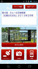
Top page of “Haebaru Tourist Navi” for smart phones.
March 5, 2013 Ryukyu Shimpo
On March 3, the Haebaru Municipal Office introduced publically accessible WiFi and, using what is called “augmented reality,” commenced a town guide app service for smart phones under the name Haebaru Sightseeing Navi. Following on from Nanjo, Haebaru is the second location in Okinawa to launch a town guide app service. It provides tourist information, GPS, a stamp rally, photographs with the town mascot character called “Haerun” and other frame functions, plus a guide map in four languages: English, simplified and traditional Chinese and Korean. This language function is the first of its kind in Okinawa. A general portal website will also open to deliver tourist, administrative and events information.
Part of the tourist-friendly area promotion project that started in 2012, the service is funded by a grant the town received from the central government. On March 3, Vice Mayor Shinsho Kuniyoshi introduced the project at the Ryukyu Kasuri Hall in Haebaru and demonstrated augmented reality on Kasuri Road. He said, “We want to use information technology to introduce our town to people both inside and outside of Okinawa.”
WiFi towers have been installed on top of the municipal office and Kasuri Hall and provide coverage for the area.
The municipal office provided 2.7 million yen in fiscal 2012 for the project, and plans to expand the WiFi system, add more functions to the app and further enhance the portal website.
(English translation by T&CT, Hitomi Shinzato and Mark Ealey)
Previous Article:Itoman Sabani boat builder wins MJC award
Next Article:Juri-uma parade performed in Tsuji
[Similar Articles]
- Majority of foreign tourists dissatisfied with WiFi services in Okinawa
- Ryukyu Kasuri Cooperative wins the Pola Traditional Culture Award
- Sunflowers in full bloom in Haebaru
- Town tour guide project starts in Nago
- OCVB calls for improvement in translation and WiFi services in Okinawa
 Webcam(Kokusai Street)