U.S. base information gathered for Okinawa environmental records to plan smooth use of returned land
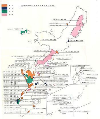
Drawing showing the position of relevant bases in the environmental records. “Okinawa U.S. base-related documents” compiled by the prefectural Department of General Affairs’ external relations division in 1972 are cited as reference materials.
June 28, 2017 Ryukyu Shimpo
The Okinawa Prefectural Department of Environmental Affairs has prepared foundational materials titled “U.S. Base Environmental Records”, which contain information regarding the use history of and accidents involving environmental pollution at U.S. military facilities in Okinawa including b
ases that have already been returned, and posted these materials on the official prefectural homepage on June 26. It is the first time that the use history of land,
categorized by facility, has been collected in an effort to provide unified information in a database. The goal of this is to facilitate smooth land-use planning f
or U.S. military facility land that will be returned in the future.
Japanese and U.S. governments in 1972.
The records cover the 87 facilities set forth in the “Facility/Area Memorandum” (the 5/15 memo) exchanged between the
In Okinawa, there have been many cases in which contamination was discovered on land returned by the U.S. military after the land was returned, such as the case of barrels containing dioxins and other harmful substances being found buried in a soccer field in Okinawa City. However, measures to return the land to its original state have been inconsistent.
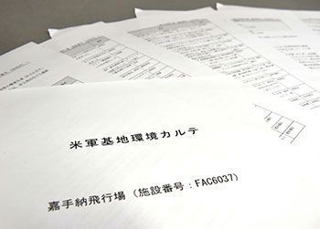
Information (partial) regarding Kadena Air Base compiled in the environmental records
Given this situation, in FY 2014, the prefectural government established a Special Management Office of Military Installation Envir
onmental Affairs, and over the course of three years until the end of FY 2016, the office compiled the aforementioned environmental records and “Okinawa U.S. Military Base Environmental Guidelines” to explicitly set forth the proper response by the prefectural government when environmental contamination deriving from U.S. military bases is discovered.
The records comprise a combination of information from interviews with Okinawans and documents from the U.S. Nat
ional Archives. In addition to basic information regarding each facility and a history of environment-related accidents at each facility, the records also contain matters to note when performing environmental surveys.
The records also contain groundwater foundation surface contour maps to facilitate prediction of water flow in the case where soil contaminants have flowed into groundwater. The information will be continuously updated, and there are plans to convert it into a GIS (Geographic I
nformation System) by the end of this fiscal year.
Fujimi Tamaki, head of the Special Management Office of Military Installation Environmental Affairs, encouraged the national government and related city, town and village governments to use the records, saying, “When land is returned or when environmental contamination comes to light, I hope the foundational information in the records is used as a basis to determine what kind of environmental survey should be performed with reference to the guidelines.”
The environmental records can be viewed on the official homepage of the Okinawa Prefectural Government (http://www.pref.okinawa.jp/site/kankyo/seisaku/karte.html).
(English translation by T&CT and Sandi Aritza)
Previous Article:A documentary film about Kamejiro Senaga to be released in August
Next Article:Coral spawning confirmed at Oura Bay
[Similar Articles]
- Specific levels of 25 toxic substances withheld at information sessionon
- Editorial: Base contamination information disclosure must precede land return plan
- OPG finds high PFOS concentrations near Kadena Air Base, advises against drinking the water
- OPG calls for an environmental assessment of Ospreys in NTA land reclamation plan
- Editorial: Pollution from Kadena reminds us that there is no choice but to revise the SOFA
 Webcam(Kokusai Street)